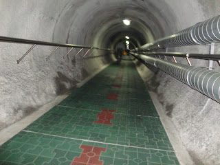
Except that we got to see them both this weekend on our second trip to Seoul.
Shortly after finishing work on Friday night, Tim and I set off on the bus/subway/train/cab journey to Seoul. We boarded the KTX (Korean Train Express) at 9:00pm and arrived in Seoul at about 11:30pm. Although the distance between the two cities is about 450km, the KTX travels at speeds of about 300km/hour making the trip a quick 2 hours and 30 minutes-including stops.
 |
| bag of lotteria for the road. |
It was a late night for us old folks (9:30pm is the usual bedtime) and we only got a few hours sleep in before waking up on Sunday to catch our tour up north.
DMZ
A very brief introduction to the DMZ:
The Demilitarized Zone (DMZ) is a 'buffer zone' between North and South Korea who have been separated since the quazi-end of the Korean war in the early 50s. I say ' quazi' because the war never actually ended, but an armistice agreement was signed by both sides agreeing to stop fighting.
I could go on about Korean War history but I won't. If you're interested, there's an excellent book covering everything imaginable called "Under the Loving Care of the Fatherly Leader" by Bradley Martin (2006).
The DMZ is the area on both sides of the North/South military demarcation line (border) and is 4km from North to South, spanning the entire width of the Korean peninsula.
The area is patrolled by military on both sides (with US troops joining the South side) and is said to be one of the most heavily militarized borders in the world.
 |
| map of the Koreas. we went to the line. |
 |
| schematic of the DMZ, the green area on the map. |
Though South Korean residents are not permitted in the DMZ (with the exception of soldiers stationed there, of course) foreign tourists are able to go on tours to certain areas of interest. We used Kooridor Tours which is run by the USO based at Camp Kim in central Seoul.
Our bus left at 8:00am and was 98% full (approx 50 passengers). This is pretty amazing, considering we were on one of three tours the company ran that day, and there are several other companies who also run tours. After ride of about 90 minutes, we stopped at the Joint Security Area (JSA) in Panjumon, the last village before entering North Korea.
At the JSA, we disembarked our tour bus and were transferred over a US soldier who gave us the next portion of the tour in the JSA. When we got off the bus we had to form 2 single file lines and wait inside the South Korean (SK) owned ' Freedom Building' where we were not permitted to take any photographs. We were warned many times not to stray from the group, make gestures to any North Korean soldiers, and just to not do anything stupid. We were require to leave all of our belongings on the tour bus - even small camera cases, and if wearing jackets, we had to keep them on properly at all times so that we couldn't be suspected of hiding something within them.
 |
| lined up in the Freedom House (illegal picture) conference row. |
After a few minutes, our soldier took us into the middle 'Mac' building on 'conference row', a series of buildings, some blue (SK), some silver (NK). These buildings are all set directly on top of the Military Demarcation line which is the official split between the Koreas. This view from the window of the MAC building shows the concrete boundary with the gravel on the South Korean side and the dirt on the North Korean side.
After our short time in 'North Korea', we returned through the Freedom House to the US supplied bus and driver and drove through the DMZ to a checkpoint where we had a view of North Korea's 'propaganda village' and their gigantic flagpole which carries a 600lbs flag, the second largest in the world. The village is so named because of its buildings which are mostly facades, some with windows and doors painted on, and many with no floors inside. This village is used by NK to entice Southerners to want to defect (move) to the North. There are also at least 2 phonebooths set up in the area with a direct line to NK if you should have a sudden urge to cross the line and defect.
 |
| blue-roofed propoganda village and the NK flag atop a 160m flagpole. |
We continued on to pass the 'bridge of no return' and the site of the infamous axe murder incident. The bridge is the place where prisoners of war passed following the 'end' of the Korean war. POWs were allowed to choose which country to go to, but after making their choice, could never return to the other side.
 |
| the bridge of no return. the rusty sign on the left marks the military demarcation line - although it's actually a few metres south. |
The axe murder incident took place in 1976 when American soldiers set out to chop down a large tree that was obstructing the view between two checkpoints in the southern DMZ. The US had not obtained permission for this endeavour and NK soldiers intervened resulting in the death of two US soldiers and injuring several others. This incident was so serious that both sides believed it might lead to war.


Jill, I always enjoy reading your blog. I learn some stuff about korea that I didn't even know before. Thx and miss you lots! :)
ReplyDelete